Sunday, July 8, 2018

Hiatus or Depression? You Decide.

When the rain gods close a door, they open a...well...
Can't fool me again! ...or something like that...
Whatever...
I'm depressed.

Every fossil excursion I've planned since May has been waylaid by heavy rain and rising water levels.
At first I was having serious digging withdrawals, then I took advantage of the opportunity to catch up on all the projects and housework that had been taking a back seat to my fossil needs.  
Now I'm caught up.
Now what?!

A year has passed since I last met up with Miss Vickie in Keokuk, Iowa
and we were both ready to do some rock hounding.
I once again combined a trip to visit family and friends in Missouri with a trip to hunt for geodes.

Vickie got a haircut outside our luxury accommodations.  All the better to stay cool when you're rockhounding in July.
It is easy to find geodes in this area. The main difficulty is breaking them open.  Last year I loaded up 5 gallon buckets of unbroken geodes only to find that when I finally opened them, the majority were duds.  Opening geodes on site saves bringing home duds but it's also hard work.  We didn't have the right chisels for the job.  After several hours of pounding, mine flattened out so that I was basically smashing the geodes open.  We'll remember that for next time.

The big advancement this year
was a handy "barge" to transport our finds along the creek.  Vickie's husband, Jim, constructed this for us and it was such a help.  He also sent 2 of his amazing custom Bloody Marys for me in Vickie's cooler.  
Joy!!!

Can you say "impetigo"?
Neither can I but, man, these creeks get gnarly in warm weather.
Add to that all the small patterned snakes swimming in the water around my feet and you've got a DEFCON 1 creep out factor.
So you may ask yourself, "Did they get out of the water?"
Nope.
Gotta find those rocks!
Doesn't this look like rock candy?  Yum!
I found plenty of geodes but not the variety of interior minerals that I found last year. 
This was different for me: a solid interior of a mineral that resembles mica. 
I wanted to bring home a biggun' this year, through the Vickie and Jim snowbird system: I send all my rocks to Wisconsin for the summer and they find their way to Florida in the fall.
This monster had been broken into several pieces and abandoned on the shore, probably because there is an unattractive mineral deposit over the crystals, but I couldn't help myself. I loaded up a few of the best chunks to work on at home.  The crystals have an interesting multifaceted shape. The biggest piece, in the photo above will come home in November.

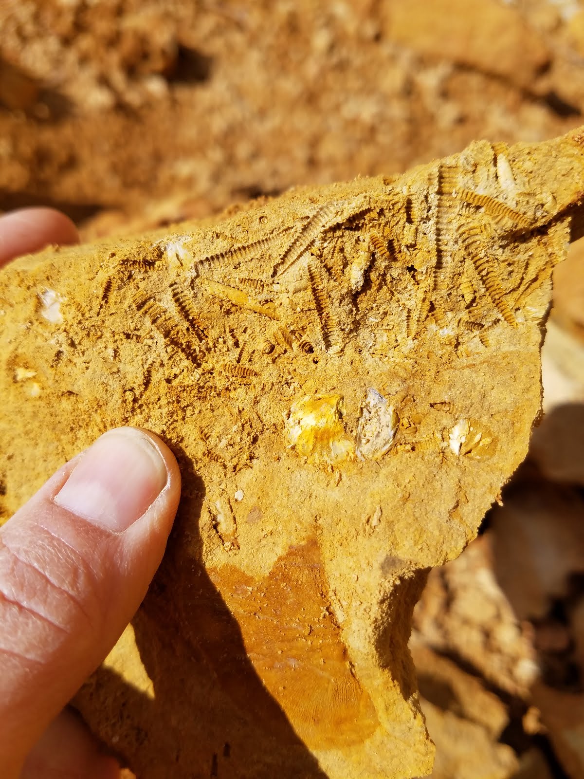
There are fossils, too!
I found a few more bits of fossilized lithostrotionella coral.
Doesn't this stuff have a nickname?!

Vickie found this pretty crinoid stem so I knuckled down and managed to scrape together a few pieces for myself:
Some interesting shell fossils as well:

This year we planned to hunt for 2 half days and one full day,
but after one half day and one full day, we opted to eat meatloaf at a local diner and head our separate ways.  
Still...as I drove out of town I couldn't help thinking, 
"Maybe just a couple hours in the creek before I go."

I know you have wondered, from time to time, about the origins of the word "mollycoddle".
Here's your answer from the World Wide Words web site.

Mollycoddling

Q From Richard Buttrey, UK: Have you any idea where mollycoddlingoriginated?
A Let’s take it in its two parts. The second comes from the verb to coddle, meaning to treat somebody in an overprotective way, as though he or she were an invalid. The verb in this sense is not recorded before the early part of the nineteenth century — its first appearance is in Jane Austen’s Emma: “Be satisfied with doctoring and coddling yourself”. It looks very much as though it comes from an older sense of the verb meaning to boil gently, to parboil. That sense is linked to caudle, an old word for a warm drink of thin gruel mixed with sweetened and spiced wine or ale, which was given chiefly to sick people. Hence, by association of ideas, coddle took on its modern sense.
The first bit is on the face of it easy enough, since it is from the pet form of the given name Mary (as in Sweet Molly Malone of Dublin’s fair city). But Molly has also had a long history in several different but related senses associated with low living. (The name was popularised by Middleton and Dekker’s play The Roaring Girl of 1611, which featured a criminal called Moll Cut-purse.) As either molly or moll, from the early seventeenth century on it was often used to describe a prostitute, hence, much later, the American gangster’s moll. As molly it was also a common eighteenth-century name for a homosexual man, often in the form Miss Molly, and a molly house was a male brothel (as in Mark Ravenhill’s new play at the National Theatre in London, Mother Clap’s Molly House).
It’s sometimes said that the molly in mollycoddle comes from the sense of a prostitute, but the usage evidence shows that it was really linked to the gay associations. As a noun, it was used particularly of a man who had been over-protected in childhood and so considered to have been made into a milksop or effeminate. For example, William Makepeace Thackeray wrote in Pendennis in 1849: “You have been bred up as a molly-coddle, Pen, and spoilt by the women”. The verb came along later in the nineteenth century and was used more like the way we do now.

Friday, May 18, 2018

C'est Fini!

It's over!
I probably write that at about this same time every year when the water level of the Peace River gets too high for digging.  
Luckily we worked in a final 3 day camping trip before the rains started, and dug our little hearts out.
I brought along a kayaking friend, Kitty, and although she is no stranger to hunting for fossils, nor kayak camping, the whole digging in the river deal was new to her.  
She did a lot of digging but also took advantage of the peace and quiet of the area.

She looks like she's reading but she's not.
She's asleep.
But before the nap, she managed to find this really cool fish jaw:


Before I get into the fossils, here's one of my more interesting and unsettling finds:

A straight razor that is still incredibly sharp.  Yucky thoughts of accidentally stepping on this the wrong way.  The name "Cheminova" is imprinted on one side and all I could find on Google was an Indian agricultural chemical company which kind of makes sense for the area.
All that being said, watch your step out there!

And now for the fossils!
I found some more glyptodont scutes including a thick double section:

A nice pre-equus tooth (I think):

I found several equus teeth which made Kitty comment that a horse must have died in that spot.  
Pam and I tried to explain how to know when things were and weren't "associated".

Here's a handful of little goodies:

Some gator teeth:

Small bison tooth:

Interesting crystalized marine items including sea urchin spines, coral, and a shell:

Antler:

Turtle:

Broken fish mouth plate, barracuda tooth, and twig/root:
(I know I'm scraping the bottom of the barrel here but I told you I didn't have a great season)

Mammoth and mastodon enamel:

And some shark teeth, always nice to find:

We made a new friend in camp:

and tried a new recipe that we will continue to perfect:
(That's butterscotch, chocolate, and marshmallow fluff on a banana)

Goodbye, dear camp!  I hope to see you again next year!

I wanted to throw in a photo of a new t-shirt I bought:


Here's some additional information from Wikipedia regarding the Bone Valley area of Florida which contains the Peace River.

The Bone Valley is a region of central Florida, encompassing portions of present-day HardeeHillsboroughManatee, and Polk counties, in which phosphate is mined for use in the production of agricultural fertilizer. Florida currently contains the largest known deposits of phosphate in the United States.
Large walking draglines, operating twenty-four hours a day in surface mines, excavate raw pebble phosphate mixed with clay and sand (known as matrix). The matrix contains a number of chemical impurities, including naturally occurring uranium at concentrations of approximately 100 ppm. Because this phosphogypsum is slightly radioactive, its use is banned in most situations.[1]
The matrix is then dropped into a pit where it is mixed with water to create a slurry, which is then pumped through miles of large steel pipes to washing plants. These plants crush, sift, and separate the phosphate from the sand, clay, and other materials, and mix in more water to create a granular rock termed wetrock. The wetrock, which is typically of little use in raw form, is then moved largely by rail to fertilizer plants where it is processed. The final products include, but are not limited to, diammonium phosphate (DAP), monoammonium phosphate (MAP) and trisodium phosphate (TSP).
Waste byproducts are stored in large phosphogypsum stacks and settling ponds, often hundreds of acres in size, and up to 200 feet (60.96 m) tall.
Phosphate processing produces significant amounts of fluorine gas, which must be treated by filtering through special scrubbers.
Much of the final product (known within the industry as 'dryrock') is transported by rail to facilities along Tampa Bay, where they are transloaded onto ships destined for countries such as China.
Phosphate product intended for domestic use is assembled into Unit trains of covered hopper cars for northbound movement.
Phosphate is a declining export to China. Previously, significant amounts of rock were shipped to China, where it was processed into phosphate fertilizer. The majority of phosphate mining in Florida is done in the Peace River watershed. Phosphate mining companies use draglines to remove surface soils up to 60 feet (18.29 m) deep over thousands of contiguous acres. Once land is mined, state law requires that it be reclaimed. Wetlands are reclaimed on an acre for acre, type for type basis. Most modern mining permits actually require companies to recreate more wetlands than were initially present on the land. More than 180,000 acres (728 km2) have already been mined and reclaimed in the Peace River watershed. As reserves in the northern portion of the bone valley are depleting, mining companies are now seeking permits for another 100,000 acres (405 km2), which will replace reclaimed mines to the north.
One byproduct of the extraction process is clay, which is stored in settling ponds and eventually comprises 30%-40% of a mine site. Some of these ponds can measure thousands of acres. Rain drains slower through these clay-laden ponds than typical soil. Critics argue that this, in turn, reduces baseflow to the Peace River. Some studies have indicated that reclaimed lands actually provide a more consistent baseflow because the sandier soils of the reclaimed land provide faster baseflow, while the clay provides a slower steady flow, creating more flow during dry periods than native land. Since the 1960s, the average annual flow of the middle Peace River has declined from 1,350 cubic feet (38.23 m3) to 800 cubic feet (22.65 m3) per second (38.23 to 22.65 m³/s). Critics argue that this flow reduction is due to phosphate mining, but studies by the Southwest Florida Water Management District have shown that the reduction in flow is due to multidecadal oscillation in Atlantic Ocean temperatures.
Critics argue that each holding pond has been perceived as a risk that threatens water quality, public health, wildlife, and the regional economy. Dams restraining the ponds have overflowed or burst, sending a slurry of clay into the river, and coating the riverbed for many miles with a toxic clay slime that suffocates flora and fauna. One such incident in 1971 killed over three million fish when 2 million US gallons (7,600 m3) of phosphate waste swept into the river, causing an estimated 5-foot-tall (1.5 m) tide of slime that spread into adjacent pastures and wetlands. Since the 1971 spill, clay settling areas are now constructed as engineered dams. No such spills have occurred from any settling areas built to these standards. The current dams withstood three hurricanes which crossed the Bone Valley in 2004.
In 2004, during Hurricane Frances, a phosphogypsum stack was overwhelmed by hurricane rains and the levees were breached, sending over 18,000 US gal (68,137 L) of acidic process water into Tampa Bay. Cargill Crop Nutrition, who owned the stack, added lime into the affected areas in an attempt to neutralize the highly-acidic runoff. Due to the extraordinary amount of runoff created by the hurricane, the spill was quickly diluted and environmental damage was minimal. In a consent agreement with the Department of Environmental Protection, Cargill greatly increased its water treatment capacity at the facility. The facility is a no discharge facility and was overwhelmed by the above normal rainfall in 2004, in addition to being affected by three hurricanes.
On occasion, clay slime spills have prevented the Peace River Manasota Water Supply Authority from using river flows for drinking water, forcing municipalities to seek water supplies elsewhere, or rely on stored supplies. On several occasions, the effects of heavy rainfall have created sinkholes beneath the settling ponds.
Most recently, in August 2016, a sinkhole opened up under a gypsum stack at the Mosaic’s New Wales fertilizer plant in Mulberry, Florida. 215 million gallons of containment water dumped into the Florida Aquifer.[3]


Monday, April 30, 2018

Checking Out New Neighborhoods

Nobody's going to tell me where to fossil hunt
on the Peace River.
Those newbie days are gone and to be fair, I'm rather withholding when it comes to divulging good digging spots as well.  
The prospecting continues.
I said I wasn't going to look at FaceBook anymore but of course, I did.
I saw a post that said, "Yesterday the river was handing out megs like candy."
Candy is one of my favorite things...
but apparently I am on the river's sh*t list.

I spent a day poking around last week
but my heart wasn't in it and several times I considered just heading home, but
fossils only come to those who dig,
so I stopped in a shallow area and started digging.
For a day that was almost a wash, I managed to find a couple of cool things.

Maybe the biggest tiger shark tooth I've found:

A super sweet little mako:

Giant armadillo scute:

Pristine shark teeth:

Two interesting shark teeth:
 

Assorted fish and shotgun shell parts:

Turtle and tortoise:

This and that:

And, of course, old whiskey bottles:
There's never an end to the alcohol related detritus on the Peace River.
Next weekend, camping!

Here's some reading info regarding collecting old whiskey or "whisky" bottles from Collectors Weekly.  Maybe if I dig deeper, I'll find the good ones.

Strictly speaking, there’s no such thing as a "whiskey" bottle in Scotland. There you will find only "whisky" bottles, hopefully filled with a single-malt Scotch by Speyside distillers such as Macallan, Balvenie, or Glenfiddich. For some, collecting such rare whisky bottles is its own reward; for others, the virtues of these bottles are best appreciated by savoring their contents. In Ireland and the United States, the word "whiskey" generally gets an “e,” while in the U.S. the term itself most commonly refers to Bourbon and rye. Bourbon is made from about 70% corn and is aged in oak barrels. Most of the biggest distillers, from Jim Beam to Maker’s Mark, are in Kentucky. Tennessee is also a center for whiskey, although its best-selling export is not labeled as Bourbon; Jack Daniel’s makes Tennessee whiskey. As for the bottles themselves, some of the earliest ones produced in the U.S. date from the beginning of the 19th century and have squat, cylindrical shapes. Less symmetrical were the so-called chestnut flasks, whose bulbous bodies tapered abruptly to a slender neck. Numerous other types of spirits bottles were produced throughout the 19th century and into the 20th (Jack Daniel’s went to its famous square bottle in 1895), but serious bottle collectors look for the figured flasks made from about 1815 until 1870. These flat-sided bottles, which were often pear-shaped or oval, featured relief portraits of U.S. presidents and patriotic symbols such as eagles on their sides. Other celebrities immortalized on antique whiskey bottles included the French General Lafayette (a hero of the revolutionary War), Jenny Lind (a famous singer of the day, who was known as the Swedish Nightingale), and DeWitt Clinton (as governor of New York, he presided over the construction of the Erie Canal).

Sunday, April 22, 2018

West Virginia Attitude Adjustment

I knew I just needed to get away from that dang river
and I'd get my head on straight.
I am so grateful to have access (through my friend) to a place where I know I'll find arrowheads.  How many people can say that?
This was my 5th annual visit
and I got to borrow some groovy rubber boots for slogging through muddy fields.
It was mesmerizing to glimpse my Austin-Power-styled feet as I scanned the ground for arrowheads.
The boots brought me luck (or at least dry comfort) because I had a very productive visit.
I'm also gaining experience in spotting tiny worked edges
 and points that are hiding out under dirt clods.
The above point is one of the best I've found on my visits.
It's better after a rain because the darker points contrast better with the soil.
I went a month earlier this year which made a big difference in the temperature.  The days were beautiful but at times there was a freezing wind that required additional protection for my schnoz.
I used an app to map our path and found that we were walking about 5 miles a day through rough fields.  That explains why something so slow and calm is so exhausting!
We might be in hillbilly country but we travel with homemade quinoa tabouleh and local IPA's.
I have my limits when roughing it.
The last point I found was so exciting:
Even a missing corner can't dim my enthusiasm for this beauty.
Here's my haul for 2018.
But did you think I wasn't going to look for fossils?
Wrong!
I went back to my little hillside for some Devonian brachiopod love (legal in West Virginia).  
See them piling up behind me?  
Right under the local IPA.
I've decided, at the age of 53, that I need to document my handstands because I never know when it will be the last.  Here's my first West Virginia handstand.  I was cold, tired, and buzzed, 
but it was a passable attempt.
I love this spot because the matrix is incredibly soft.  It doesn't split in nice plains but the hammering is so easy, I won't complain.
Lots of tentaculite impressions and even some fossil remains.  
I didn't get any trilobite love this time.  
Just one impression.  
I know they're in there! Maybe next year.
A nice collection for no more than 2 hours on the hill
 and I really only worked one small section of rock.
This photo is called,
"Get ready, TSA! Here I come!"
I find it smooths the way if I announce from the get go that I have a suitcase full of rocks.
The Charlottesville, Virginia airport is very small so it's not much of a hassle to unpack and repack everything for the hand check.  In fact, I was the only person to be seen at security.  
The West Virginia trip cleared my mind and got me ready to head back to the river.
I'm not saying I won't keep bitching and moaning if I don't find stuff, though.

For your further reading pleasure...

I was snuggled under a quilt in West Virginia and noticed this fabric tag sewn to the underside.
I grabbed my phone and looked up all the info, discovering that I was sleeping under a quilt probably made in the 1800's.  I immediately considered carefully folding it up and looking for a modern, machine washable blanket but these treasures were always meant to be used, a practical use for leftover fabric scraps in the time before WalMart and disposable clothing, bringing beauty to the home and comfort to its inhabitants.  
Here's the intro on the West Virginia Heritage Quilt Search site.  Check it out for a look into our nation's past.

<<Tucked away in the Appalachian Mountains of West Virginia, preserved for generations, handmade bed quilts are windows into the past. In 1983, three West Virginia county extension agents discussed the need to locate and document their state's historic quilts. In 1992, West Virginia Heritage Quilt Search held documentation days throughout the state to collect and preserve the valuable information stitched into these quilts.

The search focused on documenting quilts made in West Virginia before 1940, which marked the end of a fertile period in American quilt history and the beginning of a decline in quiltmaking that would continue until the 1970s. Ultimately, the search registered more than 4,000 quilts.
This effort has culminated in West Virginia Quilts and Quiltmakers: Echoes from the Hills, published by Ohio University Press on November 1, 2000, in association with the West Virginia Heritage Quilt Search, Inc. The book includes 159 color photographs of selected quilts, with maps showing where they were made, a database analysis of the statewide survey, and the oral histories of descendants of quiltmakers.>>